Advanced Road Maintenance, Asset Management, and Corridor Planning
Efficient road asset management is essential for creating safer, more durable, and sustainable road infrastructure. Veris’ RoadSiDe solution empowers you to take control of your road network with confidence, offering advanced insights into both surface and subsurface conditions for better asset management and condition assessment.
By integrating cutting-edge Ground Penetrating Radar (GPR) and Mobile Laser Scanning (MLS) technology with a secure, cloud-based platform, RoadSiDe delivers real-time, actionable data. This innovative approach enables proactive road network planning, targeted road maintenance, and optimised corridor planning, ensuring your infrastructure remains resilient, cost-effective, and ready for the future.

Comprehensive Condition Insights
Detect road wear, subsurface deterioration, and vulnerabilities early to prevent costly repairs and extend asset condition lifespan. This proactive approach ensures safer and more reliable road networks, accurate condition assessment and predictive pavement management.
Real-Time Corridor and Route Planning
Access real-time data for precise route planning, supporting oversized vehicle movements and critical transport pathways. Minimise delays, optimise operations, and enhance productivity with advanced road network optimisation tools.
Cost-Effective and Sustainable Road Maintenance
Focus road maintenance where it's needed to reduce waste, optimise budgets, and extend infrastructure lifespan. Save costs while promoting sustainability and lowering your carbon footprint through smarter asset management strategies.
Key Features
RoadSiDe combines innovative technology with user-friendly functionality to deliver actionable insights for smarter road asset management. These features ensure seamless data access, analysis, and integration, empowering proactive infrastructure decisions.
- Integrated Cloud-Based Platform: Access data securely from any device, no proprietary software required.
- Customisable Dashboards: View panoramic imagery, maps, and perform advanced queries for actionable insights.
- Predictive Analytics: Plan preventative road maintenance with future-focused data tools.
- Efficient Data Export: Seamlessly integrate insights with your existing asset management systems.
See the whole picture - above and below ground. Book your RoadSiDe demo now.
Book a DemoApplications

Routine & Preventative Road Maintenance
Streamline scheduling, assessments, and repairs using real-time data to prevent costly degradation and improve pavement management.
Asset Condition Reporting & Dilapidation Surveys
Capture accurate asset condition data and leverage predictive insights for better preparedness and efficient recovery.
Corridor & Route Planning for Oversized Vehicles
Optimise transport routes with updated corridor planning insights, ensuring safe and efficient operations.
Surface Insights with Mobile Laser Scanning (MLS)
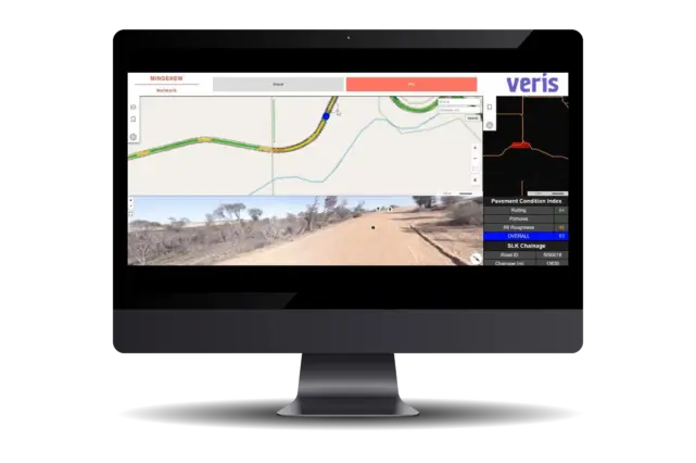
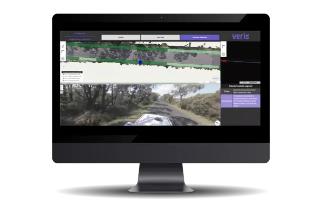
Veris utilises Mobile Laser Scanning (MLS) to capture high-resolution surface data for road asset management. MLS technology generates detailed imagery and 3D point clouds, providing precise insights into road surfaces, including wear, damage, and other surface conditions. This data integrates seamlessly into RoadSiDe, enabling stakeholders to visualise and analyse surface conditions via a centralised cloud-based platform. With MLS, RoadSiDe empowers proactive road maintenance, improved route planning, and safer, more efficient road networks.
Subsurface Analysis with 3D Ground Penetrating Radar (GPR)
Veris complements surface scanning with 3D Ground Penetrating Radar (GPR) to deliver in-depth subsurface insights. GPR identifies hidden structural issues such as voids, cracks, and material deterioration that can compromise road infrastructure integrity. This subsurface data feeds directly into RoadSiDe, enabling detailed condition assessment and informed decision-making. By combining surface and subsurface data, RoadSiDe ensures a holistic approach to road asset management, enhancing resilience, sustainability, and operational efficiency.