Delivering value from data with Veris’ suite of digital products and platforms
In today’s data-driven world, making informed decisions requires more than just information – it demands insight. Veris’ suite of digital products and platforms offer out-of-the-box, customisable solutions that transform data from multiple sources into actionable intelligence. Whether you're designing, building, or managing infrastructure assets or major urban developments, Veris’ own secure, cloud-based platforms integrate 3D data with advanced algorithms and domain expertise to deliver accurate insights – empowering you to optimise operations, reduce risk, and make smarter decisions.
Designed to meet the unique needs of industry, and leveraging the deep expertise of our multi-disciplinary team of professionals, our tools are readily available and fully customisable to support every stage of your project or digital transformation journey. From digitised condition assessments to visualisation, optioneering and advanced analytics, our products and platforms drive operational efficiency and unlock new opportunities for innovation.
Out-of-the-Box Efficiencies
Our expertly refined out-of-the-box products and platforms are tailored to meet industry demands, significantly reducing product development time. Leverage the extensive domain expertise of our professional team to drive efficiency and innovation.
Data Management and Hosting
Our products and platforms provide robust data management and hosting solutions, ensuring your data is securely stored, easily accessible, and efficiently managed.
Streamlined Stakeholder Collaboration
Create a centralised and transparent hub for real-time access to baseline data, analytics and insights, empowering collaboration across your organisation.
Our suite of available Products & Platforms

Digital Urbanism
Veris’ Digital Urbanism is a process of creating, analysing, and managing information for a masterplan or digital twin, based on virtual 3D models and true data. Gain comprehensive insights, optimise project outcomes, and ensure sustainable, future-proof planning with innovative technology and expert guidance.
Find out more
RoadSiDe
Veris’ RoadSiDe is a bespoke spatial data solution designed to rapidly identify and assess defects in road infrastructure. We integrate cutting-edge Ground Penetrating Radar (GPR) and Mobile Laser Scanning (MLS) technology with RoadSiDe to deliver real-time, actionable data.
Find out more
Photo Navigator
Photo Navigator is Veris’ web-based platform that transforms the traditional site photos and inspection process using 360° panoramic imagery, AI-driven insights, and a dynamic map to deliver detailed dilapidation surveys and asset condition reports.
Find out more
BridgeSiDe
BridgeSiDe is Veris’ bespoke, digital solution for inspecting the condition of bridges, dams, tunnels, and other infrastructure assets, all without the need for disruptive fieldwork or placing personnel in hazardous environments.
Find out more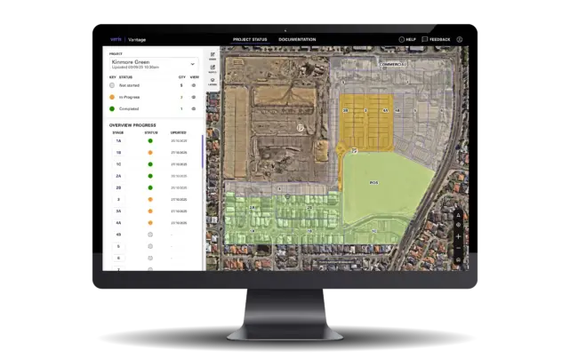
Vantage
Vantage is a Veris platform that gives developers a single source of truth. Bringing survey, spatial, approval and development data together in one live, map-based platform so you can make faster, more confident decisions. Explore how Vantage can support your next development project.
Find out more
3SiDe
Veris’ 3SiDe is a secure cloud-based data delivery, AI and visualisation platform. 3SiDe brings your data, intelligence, and people together in one collaborative platform.
Find out more