Real-time development insights for confident decisions in one dynamic platform.
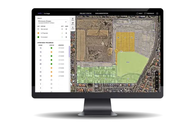
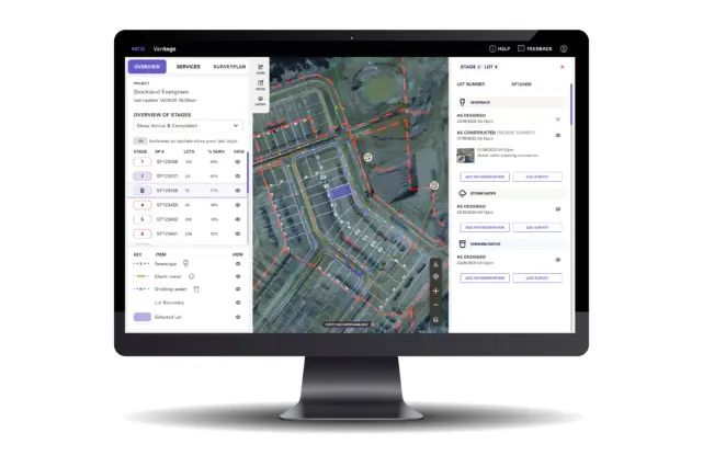
Vantage gives developers a single source of truth, bringing survey, spatial, approval, and development data together in one live, map-based platform. Now with lot-level document access, drone imagery integration, and compatibility across desktop, tablet, and mobile, Vantage helps you make faster, more confident decisions.
Explore how Vantage can support your next development project.
Why Vantage?
All your development data. A single dynamic platform. Clear insight at every stage of your project.
Managing greenfield developments is complex. Traditional surveying and reporting methods are static, costly, and disconnected from real-time insights.
With data scattered across multiple sources, developers face challenges tracking greenfield development approvals, assessing risks, and making confident, data-driven decisions.
Vantage solves this by consolidating every critical data source into one dynamic platform, providing developers with continuous visibility across accelerating approvals and reducing delivery risk. Plus, Vantage integrates with Veris’ 3D Digital Urbanism tools, enabling scenario testing and immersive visualisation for stakeholder engagement.
Vantage Features
- Online mapping, survey and visualisation tools
- Live government approval tracking and progress updates
- Access to the latest aerial imagery and survey data
- Integrated development application tracking for streamlined workflows
- Lot-level document access
- Drone imagery integration
- Mobile and tablet compatibility
- Documents page for centralised stage related and standalone plans and reports.
Vantage Benefits
- One-Stop-Shop: Access all subdivision plans, reports, and documents in one secure, easy-to-use portal.
- Boost Efficiency: Streamlined workflows shorten application timelines and improve decision-making with accurate, real-time data.
- Save Time, Work Smarter: Eliminate wasted clicks and double handling. Automated notifications deliver updates in a clear, visual format so you stay informed without chasing links.
- Equal Access, Faster Decisions: Everyone sees the same approval data as Veris, enabling transparency and speeding up decision-making.
- Track Progress with Confidence: Aerial and UAV imagery provide real-time context for construction milestones, keeping projects on track.

The Vantage Advantage
- Accelerates title processing with minimal effort
- Live data feeds from SPEAR & MetroMap
- Automated approval reporting
- Tailored for developer workflows
- Supports clearance processes beyond Victoria
- Adaptable to state specific requirements
- Built for greenfields and scalable for complex brownfield redevelopments
Book a demo and see how our online portal for subdivision approvals in Australia helps you manage projects efficiently.
Book a Demo