M6 Stage 1
Transport for NSWs $3.1 billion M6 Stage 1 includes the construction of twin four-kilometre tunnels, exit/entry ramps, shared pedestrian and cyclist pathways and tunnel stubs for a future stage of the M6. It will connect Sydney’s south to the city’s wider motorway network and will improve journey times, reduce congestion, and remove trucks from local streets.
The Challenge
Veris has been engaged by the design and construct contractors for the project, CGU, a joint venture between CPB Contractors, Ghella and UGL, to provide Project Network Control and Survey for tunnel excavation.
Our Solution
Our approach to delivering this major transport infrastructure project for Transport for NSW has been underpinned by working closely with our client on social inclusion and technical innovation initiatives.
A commitment to Aboriginal participation and inclusion
A commitment to Aboriginal participation and inclusion has been vital for a major transport infrastructure such as the M6 Stage 1. Through our alliance with Wumara Group, a majority Indigenous-owned land and construction surveying company, and our Indigenous Surveyor Employment Pathway Program, we are helping our client meet and exceed these commitments with over 40% Indigenous Participation. Wumara is playing a key role in the service delivery of the package providing engineering surveys in close coordination with Veris. In addition, the Indigenous Surveyor Employment Pathway Program graduates have been engaged as full-time trainees on the project.
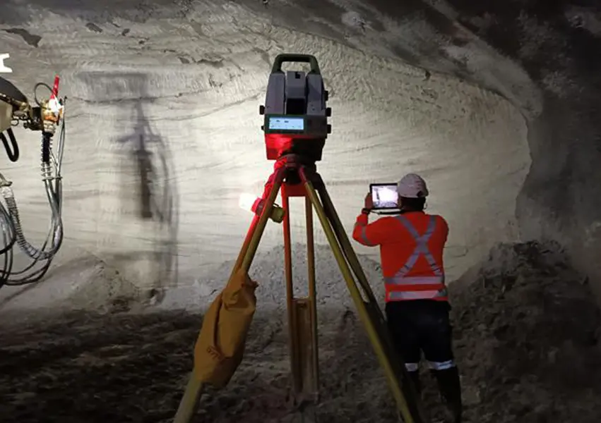
3D laser scanning delivers real-time feedback
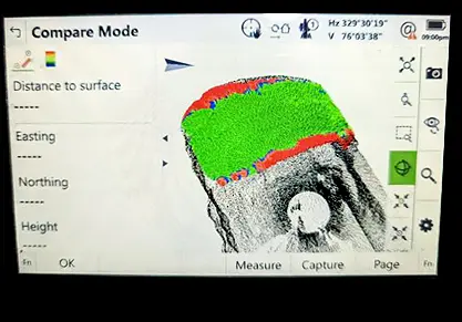
Our approach to delivering the tunnelling scope of works has been underpinned by working closely with our client on technical innovation through data capture. As part of this approach, 3D laser scanning has become a key part of the excavation cycle for the tunnels, providing significant value. Using the Leica MS60 multi-station unit and Inspect Surfaces app, our surveyors provide shotcrete thickness to nozzleman in almost real-time. Our survey team typically performs a series of scans, including initial excavation, mid spray and final shotcrete, up to six times daily. Compared to traditional surveying methods, this innovative approach has reduced re-work and improved quality and provides volumes to estimate future shotcrete needs accurately.
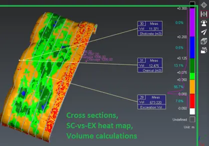
Automated point cloud processing and reporting
To streamline and speed up the processing time of tunnel reports, we have automated the processing of point cloud data. Shotcrete and excavation point cloud data is processed, cleaned and merged in Cyclone 3DR at regular intervals throughout the day using scripts developed by our team. The master point cloud is also updated daily, and a series of automated reports are generated including highly detailed 3D heatmaps, conformance reports, volume calculations and cross-section profiles. By investing in the upfront development of scripts and data management, we have provided significant productivity gains and delivered data and insights that support better decision-making and conformance on the project.
Outcomes
Our team is supporting the following outcomes on this ongoing project.
- Meeting and exceeding Indigenous participation requirements.
- Reduced re-work, improved quality and enhanced estimating in the application of shotcrete.
- Increased productivity by automating point cloud processing and reporting using scripts.