Paradise Gorge
A section of the Tasman Highway at Paradise Gorge near Orford runs below a large dolerite rock buttress. As part of its work to maintain a safe road network, the Department of State Growth in Tasmania had been proactively monitoring the stability of the rock face when it was determined that due to the ongoing environmental effects of erosion, a section of 30 metre tall dolerite rock presented an unacceptably high risk to the public. As a result, the highway was closed for 6-weeks to perform emergency remediation works involving the removal of over 2,000 tonnes of boulders from the rock face.
The Challenge
How could spatial data and intelligence be used to inform, assess and protect against the risk of a rock fall? Working closely with the Department of State Growth and engineers pitt&sherry, we were initially engaged to support a detailed survey of the area to assess the risk. Once the decision was made to close the road and remove the rock, we worked closely with stakeholders to monitor the stability of the site and perform daily surveys to plan and track progress of the remediation works.
Our Solution
Our approach unlocked a powerful mix of data capture, automated 24/7 monitoring and 3D visualisation and analysis to provide a Digital Twin solution
Using 3D models to assess the risk
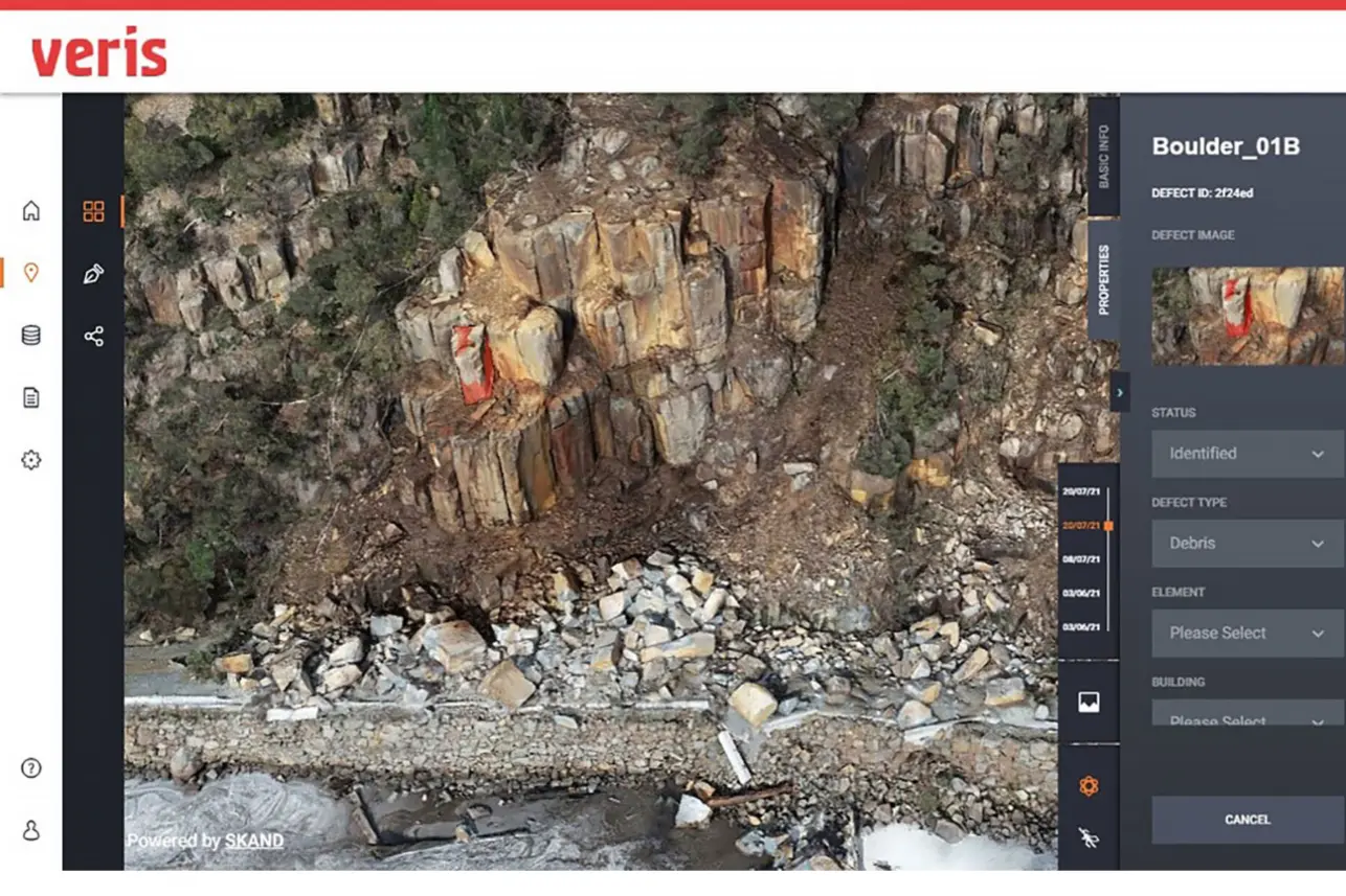
To support geotechnical engineers in assessing the risk of a rockfall, we delivered a highly detailed 3D model of the rock face. With access limited due to safety concerns, traffic management and a river running alongside the road, we combined multiple types of data capture technology including UAV surveys, photogrammetry and terrestrial laser scanning from safe access zones. The end result was a photorealistic 3D point cloud, mesh and terrestrial orthomasaic with accuracies of around 1 to 2 mm and almost total coverage of the wall, including the obscured cracks and crevices. The 3D model ultimately confirmed the identification of a critical boulder, and others of a high level of significance, resulting in the decision to close the road and commence remediation works.
Planning and tracking project progress remotely
Once remediation works commenced, Veris surveyors tracked progress via daily UAV inspections and photogrammetry. Each morning UAV inspections were performed before contractors were allowed onto the site. This not only supported assessing risks, site conditions and project progress, but it was also a useful tool in troubleshooting the removal of boulders using the airbag system.
High-resolution 3D reality models were then developed and made available via our cloud-based 3D spatial data platform – 3SiDe, which can be viewed and shared through any web browser. This provided stakeholders with an immersive digital representation of the escarpment for engineers to visualise, measure, assess, plan and collaborate on the removal of boulders without the requirement to physically travel to the hazardous site. Advanced volumetric analysis was also utilised to calculate the quantity of material removed.
Real-time data and alerts to ensure site safety
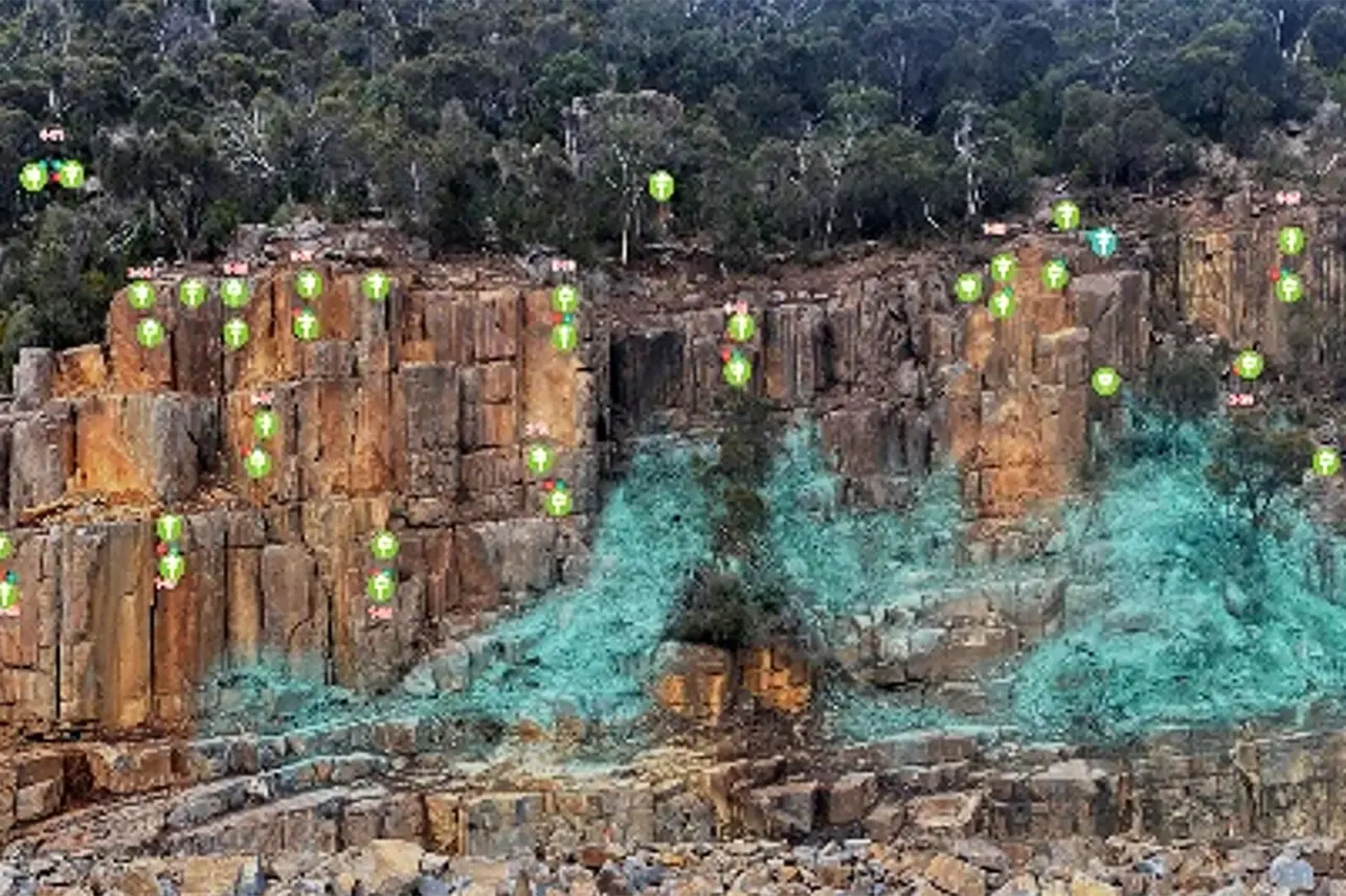
Throughout the duration of the project, a fully automated 24/7 monitoring system was deployed to continuously monitor the stability of the site. A solar powered Automated Total Station (ATS) was installed on the opposite riverbank which provided the ideal vantage point to monitor an array of 40 prisms installed throughout the rock face. An array of 30 Senceive tri-axial tilt sensors were also installed to provide precise tilt readings on individual boulders.
All sensor data was streamed in real-time via 4G communications to Veris secure servers running an in-house hosted monitoring platform. A web-based monitoring portal was also provided to project stakeholders to enable visualisation and analysis of site conditions and configured to send automated alarms via email and SMS in the event sensors exceeded predefined limits.
Outcomes
The project demonstrated how government, consultants and contractors can collaborate under pressure with short time frames and public scrutiny to deliver an outcome that was:
- Delivered efficiently and safety.
- Improved the knowledge basis and risk predictability of the site.
- Informed public understanding of the risks and value of the project.