Pavement Analysis
The Challenge
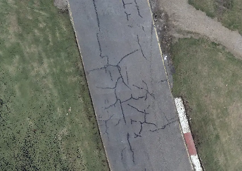
With cracking occurring on a section of the roadway, our client wanted to determine if there was a correlation between subsurface defects and surface cracks. Traditional methods had been unable to resolve the issue, and it was unclear as to why the cracking was occurring.
Our Solution
To provide detailed pavement analysis and data-driven insights into the potential causes of the surface cracks, we deployed innovative 3D Ground Penetrating Radar (GPR) technology, combined with mobile laser scanning (MLS), and traditional engineering survey methods. This approach provided a high-quality 3D dataset of both the surface and subsurface.
Deploying innovative 3D Ground Penetrating Radar
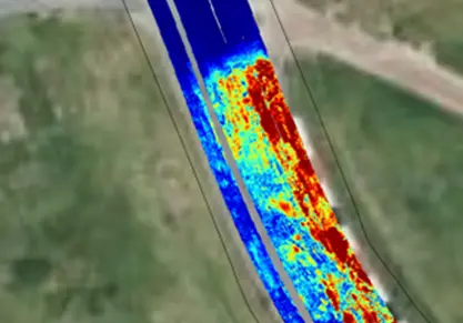
To fully investigate the potential causes of the surface cracks, we needed to capture both shallow and deep subsurface data including pavement layer depth / thickness, sub grade and road base depth / thickness, relative moisture content, underground services, and anomalies such as delamination, voiding and cracking. We also required a solution that enabled rapid data capture, for potential wider application on the racetrack.
Our solution involved deploying the innovative Kontur GroundTM 3D GPR unit to provide a unique combination of high-resolution, near-surface imaging and deep penetration capabilities. The unit was vehicle-towed at 22 km per hour and achieved 4 metre depth penetration, enabling for a high-quality data set that was captured rapidly.
Mobile laser scanning for rapid, detailed surface capture
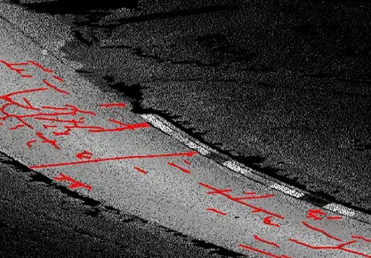
To provide detailed data capture of road defects at the surface level, Mobile Laser Scanning (MLS) was also performed. The resulting point cloud was analysed using the TopoDOT Road Analysis addon in MicroStation, to highlight road cracking and anomalies using a semi-automated process.
Engineering surveys to complete the dataset
To ensure complete dataset for analysis and validation, we also performed engineering surveys with a total station, as well as utility surveys, surface water drainage surveys, and non-destructive digging (NDD) for shallow services.
Outcomes
By using an innovative combination of technologies, we were able to perform a series of observations on the cracking in the bitumen layer. The subsequent analysis of the data was able to show the likely causes of the cracking.
Some of the key interpretations of the data included:
- Anomalies position and depth - cracks were evident until 0.12m below surface with little to no cracking evident in the northern area of the roadway section.
- Depth of bottom of road base - cracking is occurring where the road base is thinner.
- Relative moisture content – cracking is occurring where there are higher levels of moisture content.
To verify the data, test boreholes for asphalt thickness were conducted and the Kontur GroundTM 3D GPR unit was found to be accurate to within 10mm or exact.
Taking into consideration these findings will help our client decide on the best approach to manage the road surface into the future.