North West Coast Underwater Bridge Inspections
The North-West Underwater Bridge Inspection Project encompasses a set of critical infrastructure bridges situated along the North-West Coast of Tasmania. These bridges are susceptible to flooding due to their location along major rivers, and over the years, they have experienced damage from floods, such as debris and scour of abutments and piers.
Our client aims to improve monitoring of these sites topography to ensure the stability of structures. This monitoring will enable proactive planning and execution of remediation tasks when needed, ensuring the safety and longevity of these vital bridges.
The Challenge
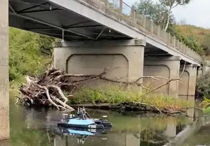
Traditionally, the underwater bridge inspections have relied on diving-based assessments. However, this approach presents numerous challenges and safety risks, such as conducting inspections in near-zero visibility water conditions and risks to diver safety through potential entanglement with flood debris. Furthermore, reports generated from these diver-completed surveys often lack comprehensive scope and do not use geo-referencing, hindering future comparisons and in-depth spatial analysis of riverbed changes. Our client engaged Veris to conduct a comprehensive resurvey of the bridges. The aim was to accurately identify changes in riverbed conditions and highlight any increases in scouring or undermining that may pose risks to the bridge structures.
Our Solution
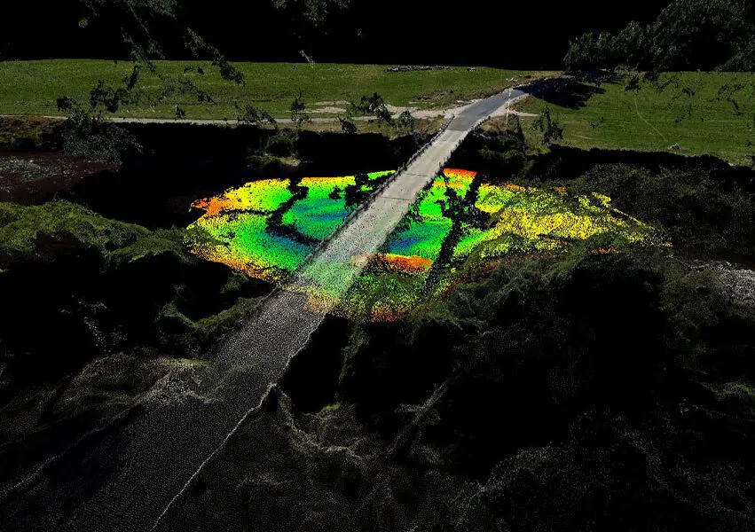
Veris performed underwater bridge inspections by utilising cutting-edge remote boat technology, integrated with advanced sensors including multibeam sonar, inertial navigation systems (INS), and 3D modelling. This approach significantly enhanced safety compared to traditional dive inspections.
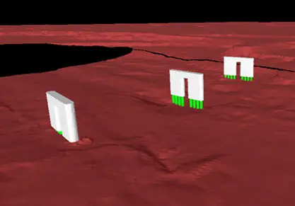
Veris deployed state-of-the-art remote hydrographic boats, enabling a two-person team to safely and effortlessly launch these boats near each bridge. Equipped with a multibeam sonar system paired with the INS to allow a real-time geo-referenced point cloud to be collected. Veris’ in-house modelling team leveraged this data along with historic design drawings to model the bridge structures as ‘Digital Twins’.
The data was then delivered to the client in Veris’ cloud-based viewer, 3SiDe. This platform enabled the viewing of both the ‘digital twin’ of the bridge and the survey data as separate layers. Thanks to precise geo-referencing, online tools facilitated accurate measurements of scour levels on bridge piles and the length of piles remaining below the riverbed. Users could capture and log these measurements as points of interest (POIs) or defects. These POI’s can then be easily shared with other stakeholders such as engineers or contractors to facilitate remediation works.
Outcome
The result was delivered in an online 3D experience, enabling defect measurement, annotation, and seamless data sharing with stakeholders. The use of Veris’ cloud-based 3D point cloud viewer, 3SiDe, aims to integrate various data resources, including aerial photogrammetry and 3D ground penetrating radar (GPR). This integration allows for a comprehensive view of the entire bridge structure, both above and below the water, all within a single platform.
Given the growing threat of increased flood events in the future, the ability to conduct safe bridge surveys for stability monitoring becomes increasingly crucial. Veris is actively refining a consistent and dependable way of scanning bridges to monitor scouring and undermining. Combining 3D-modelling skills, hydrographic expertise, and strong field craft, Veris has delivered a user-friendly solution that allows stakeholders to make informed business decisions efficiently and effectively.
By employing remote boat technology, Veris has not only enhanced the safety of data collection but also improved the safety of divers working in these challenging environments. This project has combined several surveying technologies and processing techniques to deliver a bespoke solution for the client. Additionally, Veris have established a safety-focused methodology and workflow for the ongoing monitoring of such structures.