West Gate Tunnel Asset Inspections
Reimagining Engineering Assessments Through Reality Capture and Automation
The Challenge
Delivering Level 1 Inspections for Asset Handover
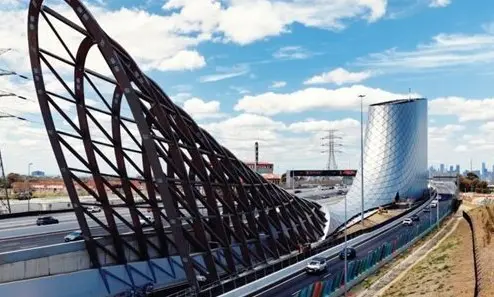
The West Gate Tunnel Project is one of Victoria’s most significant infrastructure developments, designed to transform connectivity and ease congestion across Melbourne. As the project neared completion, our client was required to deliver comprehensive Level 1 inspections as part of the asset handover process.
This task posed considerable challenges. The inspections needed to cover an extensive corridor of bridges, ramps, and associated structures within compressed timeframes. Traditional methods were impractical due to restricted access, traffic management requirements, and the sheer scale of assets involved. Thousands of images had to be captured, organised, and interpreted to produce accurate engineering reports—all while minimising safety risks and avoiding disruption.

Our Solution
Digital Reality Capture and Photo Navigator Platform
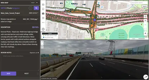
Veris provided a comprehensive digital inspection solution, combining multi-modal reality capture with our Photo Navigator platform. This enabled the client’s engineering teams to conduct efficient, accurate assessments from their desktop.
Multi-Modal Reality Capture Program
We deployed a multi-modal reality capture program using helicopter, UAV, boat, vehicle, and backpack platforms to collect imagery from multiple angles and link it to precise, geo-referenced location data. This ensured every asset was documented comprehensively and accurately. The use of 360° cameras ensured a complete and immersive visual record.
Streamlined Workflows with Photo Navigator
The unified dataset was delivered through Photo Navigator, an online interactive dashboard accessible via standard web browsers. The platform provides intuitive search and navigation functionality, allowing users to query specific asset types—such as bridges, gantries, noise walls, or retaining walls—and instantly view associated imagery. Engineers can quickly locate images using search, naming conventions, descriptions, and timestamps.
Through Photo Navigator, users could:
- Navigate assets virtually without stepping into the field
- Annotate defects and issues directly on high-resolution imagery
- Access accurate location data for every asset to support reliable reporting
Automation for Efficiency
AI-generated descriptions were applied across more than 30,000 images, creating a first-pass interpretation of each asset. These annotations serve as a valuable pre-screening tool to prioritise areas requiring closer inspection and streamline desktop assessments. In addition, images were automatically grouped by asset, eliminating hours of manual effort typically required to collate defect photos.
Crucially, the workflow also automated the generation of over 150 inspection reports, saving significant engineering time compared to traditional manual processes. This end-to-end automation enabled engineers to focus on analysis rather than administration, accelerating project delivery and improving data consistency.

Outcomes
Faster Inspections, Safer Operations, Better Data
By integrating Photo Navigator with advanced reality capture workflows, the project delivered measurable improvements in efficiency, safety, and digital asset management:
- 150+ inspection reports automated, eliminating hours of manual engineering effort compared to traditional inspection methods
- Streamlined digital workflows, reducing time spent on collation and report preparation through automation and virtual inspection processes
- Improved safety, removing the need for traffic management and minimising on-site exposure
- Enhanced data accessibility, providing a structured, geo-referenced dataset for ongoing asset management and final project handover
Beyond meeting immediate project requirements, this approach demonstrated a scalable and repeatable model for major infrastructure inspections. By combining comprehensive imagery capture, accurate asset mapping, and Photo Navigator’s advanced capabilities, Veris set a new benchmark for efficiency, safety, and data quality in engineering assessments.
Client Testimonial
“Working with the Veris team on the West Gate Tunnel Project Asset Inspections was an extremely positive experience. The team were proactive, collaborative and highly efficient on a project with very challenging timeframes. The Photo Navigator web-based platform was exactly what we had asked for and they delivered all outputs to a high quality, taking on feedback from the engineering team in a positive and helpful way.”
— FSC Engineering Team