Duck River Nature Trail
Duck River is a perennial stream and southern tributary of the Parramatta River in Sydney. The river threads its way across the urban and industrial landscape and is home to a number of important ecological communities.
The Challenge
The City of Parramatta is undertaking investigation works for the proposed Duck River Nature Trail Project, which includes a walking and cycling nature trail along Duck River. As part of the preliminary investigation works for the project, the City of Parramatta engaged Veris to provide spatial data and consultancy services for boundary identification, land acquisitions and preservation of survey marks (POSI), as well as preliminary research on titles and surrounding Deposited Plans (DPs).
Our Solution
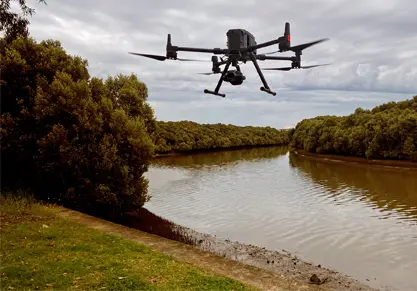
Given the intertwined and complex mixed-use landscape along the river, it was vital to have an accurate and up-to-date spatial relationship between the built infrastructure, the environment and the cadastre. As a result, we combined our leading-edge capabilities in UAV (unmanned aerial vehicle) surveys and 3D visualisation with the knowledge of our highly experienced team of Land Surveyors to provide a complete solution to the City of Parramatta.
Deploying UAV photogrammetry
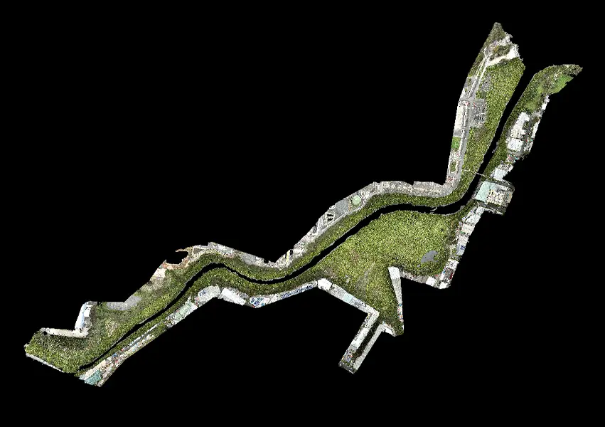
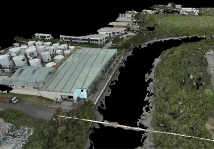
We deployed Unmanned Aerial Vehicle (UAV) photogrammetry to capture in high definition the Duck River extents. An M300 UAV with a P1 42-megapixel camera, using nadir and oblique techniques completed the data capture to provide an accurate and comprehensive photorealistic mesh. A key consideration was to capture the river at low tide.
The resulting images and 3D reality mesh provided an immersive digital replica to support the initial boundary identification and land acquisition planning stages.
Cloud-based data delivery
To support data sharing and collaboration, the high-quality datasets were delivered to the City of Parramatta through our cloud-based data delivery platform, 3SiDe. This also provides a platform for potential stakeholder and community engagement into the future including elements such as 3D visualisation through a web browser.
POSI surveys
For the POSI component, we performed an initial desktop audit including a review of the existing cadastre, creation of a Survey Mark Audit Schedule (SMAS) and a Survey Project Plan (SPP). We then carried out a field audit with GPS to identify whether the survey marks are safe or gone and to coordinate each point.
Titles and surrounding DPs
We conducted preliminary research on titles and surrounding DPs, showing the Lot/DP, Owner, Easements, Dealings, Notations.
Outcomes
Our approach to performing these works is providing the following outcomes for the City of Parramatta:
- Better analysis capabilities through high quality, immersive 3D data in comparison to traditional survey techniques.
- Risk mitigation and increased safety by undertaking the majority of the work remotely.
- Efficiency gains through the use of innovative technology for a large and sometimes inaccessible site.
- Accurate identification of the existing cadastre to ensure if any of the marks are damaged during the construction process, we can easily reinstate new survey marks.