Hydro Tasmania
The Tasmanian Hydro Electric power scheme comprises a network of 54 dams, 30 hydro-electric power stations and two major windfarms. Often referred to as “the battery of the nation” it is Australia’s largest water manager and generator of renewable energy delivering an energy future that is clean, reliable, and affordable.
Veris have been a long-term preferred supplier of geospatial consulting services to Hydro Tasmania and provide a wide range of services which include:
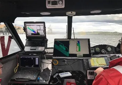
- Hydrographic surveying via multi-beam and 3D scanning sonar.
- Sub-millimetre Industrial Metrology and Dimensional Control for power station refurbishments.
- Aerial mapping and asset inspection via fixed wing and rotary wing UAV systems.
- 3D modelling and development of digital twins of small and large assets.
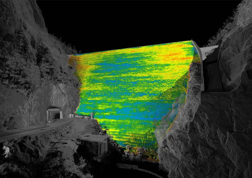
- Precision monitoring of assets including dams, pipelines and tunnels.
- Spatial analysis & fusion of multi-sensor datasets.
Hydrographic Survey
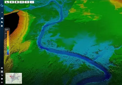
Our Hydrographic division has been engaged to complete large scale bathymetric surveys of Hydro Tasmania’s dam assets to better understand storage volumes, silting and update charting of navigable waterways.
Our unique underwater 3D scanning sonar technology is an invaluable technology for underwater condition assessments of dam walls, abutments and appurtenant structures such as intake towers to provide spatial intelligence on underwater asset integrity.
Our Hydrographic services have enabled Hydro Tasmania to obtain a greater understanding of the condition of their underwater assets and therefore more effectively quantify and plan remediation efforts for major refurbishment works.
Industrial Metrology
Veris’ industrial metrology engineers and dimensional control experts have significantly reduced the time and effort required to refurbish power station turbines.
Tasks that traditionally required days can now be completed in a matter of hours using Veris’ Laser Trackers and 3D Laser Scanning capabilities which are capable of measuring to accuracies better than 50 microns. By using advanced dimensional control techniques, Veris can simulate virtual assemblies for complex rotating machinery to firstly identify non-conformances and consult on the necessary rectifications to achieve optimal specifications.
Aerial Survey
The only way to truly appreciate the scale of Hydro Tasmania’s assets is from the air. Veris have been instrumental in providing large scale aerial inspections and 3D mapping of Hydro Tasmania’s assets for a wide variety of applications.
With the capability to deliver LiDAR, photogrammetric and thermal imaging, Veris offer unmatched Aerial inspection and mapping capabilities with a fleet of rotary-wing UAV, fixed-wing UAV and the ability to capture from manned aircraft when required.
Throughout our relationship with Hydro Tasmania, Veris has continued to demonstrate it has the depth of expertise and technology to continuously innovate and complete multi-disciplined spatial data capture and analysis projects often in challenging and remote environments.